<?xml version="1.0" encoding="utf-8"?>
<feed xmlns="http://www.w3.org/2005/Atom">
	<title type="html"><![CDATA[Forum - Et maintenant on applique ;-)]]></title>
	<link rel="self" href="https://forum.meteo-reunion.com/extern.php?action=feed&amp;tid=1807&amp;type=atom" />
	<updated>2021-01-19T15:00:17Z</updated>
	<generator>PunBB</generator>
	<id>https://forum.meteo-reunion.com/viewtopic.php?id=1807</id>
		<entry>
			<title type="html"><![CDATA[Re: Et maintenant on applique ;-)]]></title>
			<link rel="alternate" href="https://forum.meteo-reunion.com/viewtopic.php?pid=5018#p5018" />
			<content type="html"><![CDATA[<p>En ce moment quand tu prends le temps d&#039;écrire, faut sortir le popcorn et apprécier. Je kiffe ! ????</p>]]></content>
			<author>
				<name><![CDATA[axou974]]></name>
				<uri>https://forum.meteo-reunion.com/profile.php?id=8</uri>
			</author>
			<updated>2021-01-19T15:00:17Z</updated>
			<id>https://forum.meteo-reunion.com/viewtopic.php?pid=5018#p5018</id>
		</entry>
		<entry>
			<title type="html"><![CDATA[Et maintenant on applique ;-)]]></title>
			<link rel="alternate" href="https://forum.meteo-reunion.com/viewtopic.php?pid=5016#p5016" />
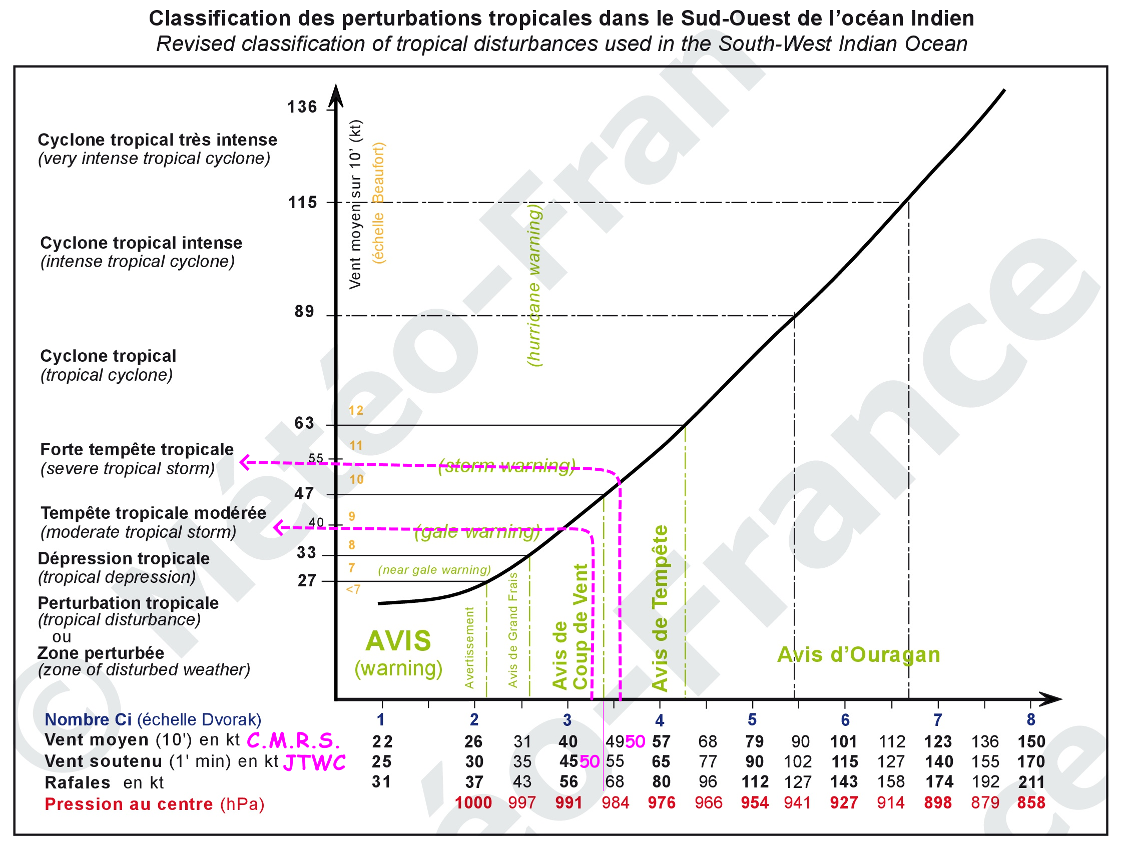
			<content type="html"><![CDATA[<p>Bonjour</p><p>Merci à <a target="_blank" href="https://www.meteo-reunion.com/le_forum/index.php?tid=1806">LeHochet2013</a> de m&#039;avoir tendu de quoi m&#039;amuser...</p><p><strong>DONC</strong>, rappelez vous, à 10h00 (heure Réunion) le <strong>C.M.R.S.</strong> nous dit :<br />5.A MAX AVERAGE WIND SPEED (10 MN): <strong>50 KT</strong></p><p><strong>ET</strong> pour 10h00 (heure Réunion) le <strong>JTWC</strong> nous dit (merci Google pour la traduction...) :<br /></p><div class="quotebox"><blockquote><p>L&#039;INTENSITÉ INITIALE EST ÉVALUÉE À <strong>50 KTS</strong> SUR LA BASE DES ESTIMATIONS D&#039;INTENSITÉ ACTUELLE MULTI-AGENCES DVORAK DE T3.0-3.5 (45-55 KTS) ET D&#039;UNE IMAGE ASCAT PARTIELLE METOP-B 190608Z AVEC UNE COUPE DE VENTS DE 45-50 KT AU SUD-EST DU LLCC.</p></blockquote></div><p>A mais c&#039;est parfait, ils sont d&#039;accord... </p><p>Ah que neni...</p><p>Et attention ceux qui ne suivent pas, je vais sortir mon fouet... c&#039;est un hochet comme un autre <img src="https://forum.meteo-reunion.com/img/smilies/lol.gif" style="vertical-align: middle;" width="25" height="38" alt="lol" /> </p><h5>Et pourquoi <strong>50 kt</strong> n&#039;est pas égale à <strong>50 kt</strong> ?</h5><p>Car rappelez-vous, le <strong>C.M.R.S.</strong> cause en <strong>vent en moyen sur 10 minutes </strong> alors que le <strong>JTWC</strong> lui y cause déjà dans une langue étrangère et en plus en <strong>vent soutenu sur 1 minute</strong>...</p><p>Et voilà comment un système peut-être une <strong>Forte Tempête Tropicale</strong> pour l&#039;un qui cause une langue connue et une <strong>Tempête Tropicale Modérée</strong> pour l&#039;autre qui va perdre demain son &quot;meilleur&quot; président depuis que la Terre existe...</p><p>Et encore mieux, démonstration en image <em>(cliquez sur l&#039;image pour la voir en grand...)</em> :<br /><a target="_blank" href="https://www.meteo-reunion.com/le_forum/Classification_des_perturbations_tropicales_dans_le_Sud-Ouest_de_l_ocean_Indien_50kt.png"><span class="postimg"><img src="https://www.meteo-reunion.com/le_forum/Classification_des_perturbations_tropicales_dans_le_Sud-Ouest_de_l_ocean_Indien_50kt.png" alt="https://www.meteo-reunion.com/le_forum/Classification_des_perturbations_tropicales_dans_le_Sud-Ouest_de_l_ocean_Indien_50kt.png" /></span></a></p><h5>Et en terme de vent <strong>sur mer</strong>, ça fait quoi comme différence ?</h5><p>Le sujet de la différence de vitesse de vent entre une <strong>Tempête Tropicale Modérée</strong> et une <strong>Forte Tempête Tropicale</strong> avait déjà été abordé la nuit précédant le passage de <strong>FAKIR</strong> dans ce message : <a target="_blank" href="https://www.meteo-reunion.com/le_forum/index.php?id=1840">C.M.R.S. vs JTWC...</a>...</p><p>La problématique est un peu différente dans le cas d&#039;<span style="color:deeppink"><strong>ELOISE</strong></span> car le chiffre de la vitesse de vent est le même...</p><p>Pour passer de vent soutenu en vent moyen, on applique un facteur de conversion de 0,88...</p><p><strong>DONC</strong> 50 kt <strong>JTWC</strong> = 44 kt <strong>C.M.R.S.</strong>...</p><p>Une différence de <strong>6 kt</strong> soit <strong>11,112 km/h</strong>... pas de quoi fouetter un chat au stade d&#039;une tempête...</p><p><strong>MAIS</strong> cette différence donne un système qui n&#039;est pas classé au même stade par les deux agences humaines...</p><p>Li<span style="color:yellow"><strong>o</strong></span>nel<br /><a target="_blank" href="https://www.meteo-reunion.com/">www.mete<span style="color:orange"><strong>o</strong></span>-reuni<span style="color:red"><strong>o</strong></span>n.com</a></p>]]></content>
			<author>
				<name><![CDATA[Lionel]]></name>
				<uri>https://forum.meteo-reunion.com/profile.php?id=2</uri>
			</author>
			<updated>2021-01-19T12:48:55Z</updated>
			<id>https://forum.meteo-reunion.com/viewtopic.php?pid=5016#p5016</id>
		</entry>
</feed>